Review Article 
![]() Creative Commons, CC-BY
Creative Commons, CC-BY
The Causes and Consequences of Air Pollution: The Case of Athens
*Corresponding author: Efthymios Spyridon Georgiou, Company Efthymios Georgiou, Stathogianni 4, 11741, Athens, Greece.
Received: August 06, 2025; Published: August 18, 2025
DOI: 10.34297/AJBSR.2025.28.003649
Abstract
This study investigates the causes and impacts of air pollution within the municipality and metropolitan area of Athens. The objective is to enhance the understanding of prolonged urbanization processes, road network infrastructure, topographic digital mapping, health-related pollution indices, and prospective urban planning strategies. The methodology integrates both theoretical frameworks and empirical analyses. Urbanization is examined through the lens of urban design principles, including the techniques and approaches employed. Furthermore, the benefits and limitations of existing transportation networks are assessed. The findings synthesize the environmental and health consequences of air pollution in Athens, which ranks among the cities with the highest pollution levels, and provide evidence-based recommendations for future interventions. Emphasis is placed on the need for sustainable, low-cost green energy solutions to improve public health outcomes, extend life expectancy, and safeguard vulnerable populations.
Territorial and Governance-Related Determinants
The Athens region is classified as both an urban and metropolitan area. Over time, the historic city of Athens has undergone progressive urban expansion, resulting in the extension of its boundaries. Currently, the term “Athens” encompasses not only the central city-Greece’s historical and administrative capital-but also the surrounding suburbs and municipalities that constitute the broader Athens Metropolitan Area, situated within the Athens Basin (Attica). The designation “administration” refers to the European administrative hub in the northeastern Mediterranean, which includes the Greek capital, the Attica region, the municipality of Athens, and its constituent districts (Figure 1,2).

Figure 1: Districts of Athens.

Figure 2: Municipality Athens.
Geographically and administratively, Athens is situated within Europe. Greece has been a member of the European Union (EU) since 1981 and is also part of the Eurozone, which adopts the euro as its official currency, the Schengen Area, enabling passport-free movement, the Council of Europe, and NATO. Consequently, Athens is politically and administratively integrated within the frameworks of Europe and the European Union. The (Figure 3,4) present the corresponding corresponding area of the city of Berlin.

Figure 3: City Berlin.

Figure 4: Berlin in Europe.
The Configuration of Road Network
(Table 1) (Figures 5,6).

Table 1: Presents the Road Network Indices for Athens and Berlin. The study conducts a comparative analysis between Athens and one of the largest cities in the European Union, highlighting that the number of private vehicles has not markedly declined in either urban area. In Germany, policy interventions have driven significant changes in road network infrastructure, whereas in Athens, developments have predominantly focused on the expansion of the metro system to improve public transportation. Notably, Berlin records the highest vehicle ownership rates per 1,000 inhabitants across several districts. In contrast, Athens exhibits the greatest road density, particularly in areas characterized by a high concentration of roads within a limited geographic space.

Table 2: Presents the relevant indices and their associated values. The manuscript investigates the key factors driving variations in air pollution levels.

Figure 5 & 6: present a comparative analysis between Athens and Berlin, demonstrating that the number of vehicles per 1,000 inhabitants is disproportionate relative to the urban surface area in both cities. While Athens has a marginally lower total number of vehicles compared to Berlin, its considerably smaller urban area leads to a higher vehicle density. This increased spatial concentration is associated with elevated noise and air pollution levels in Athens, thereby intensifying environmental and public health concerns.
Nitrogen Dioxide Index
Nitric Oxide (NO) is oxidized in the atmosphere to form nitrogen dioxide (NO₂), which exhibits a color range from colorless to brown in its liquid phase. Nitrogen dioxide has a boiling point of 21.15°C [1]. Epidemiological research has linked ambient NO₂ exposure to increased mortality rates; however, it remains unclear whether NO₂ acts as a direct causal agent or serves as a surrogate marker for other pollutants, such as particulate matter [2]. Acute exposure to high concentrations of NO₂ in enclosed environments has been associated with severe toxicity, including fatal outcomes. Furthermore, ambient NO₂ exposure may enhance susceptibility to respiratory infections by modulating immune system function [3].
(Figures 7 through 10) present nitrogen dioxide concentration levels within the municipality of Athens for the period from 1 September 2024 to 1 July 2025. The analysis is focused on the municipality of Athens, with red shading representing the highest concentration levels. The concentration ranges are categorized as follows: [1.0E-4, 8.75E-5], [6.25E-5, 3.75E-5], and [1.25E-5, 0].

Figure 7: Nitrogen Dioxide in Municipality of Athens 01-09-2024.

Figure 8: Nitrogen Dioxide in Municipality of Athens 01-01-2025.

Figure 9: Nitrogen Dioxide in Municipality of Athens 01-04-2025.

Figure 10: Nitrogen Dioxide in Municipality of Athens 01-07-2025.
Weather Digital Products
In today’s highly interconnected global society, digital devices such as smartphones, tablets, and computers play a pivotal role in the dissemination and consumption of weather observations, forecasts, climate projections, and information pertaining to global climate change [4]. Following decades of technological advancement, society has fully transitioned into the digital era, wherein digital Information and Communication Technologies (ICTs) are deeply embedded within the built environment [5].
The wide range and uneven quality of digital weather apps can produce conflicting information, making it harder for users to interpret and act on important weather data. Moreover, although smartphones enable rapid dissemination of weather warnings, the presence of such alerts has not consistently translated into increased public adherence to recommended protective behaviors, such as seeking shelter [4]. The complex interactions between ICTs and environmental impacts necessitate thorough evaluation, with qualitative studies highlighting both potential risks and opportunities arising from the ongoing information revolution [6].
(Figure 11) depicts a proxy measure of humidity, specifically the mean annual vapor pressure in Athens for the year 2025. Values range from 1.10 to 1.20 kPa, with the lowest values indicated by dark blue and the highest values, exceeding 1.30 kPa, represented in yellow.

Figure 11: Mean Annual Vapor Pressure.
(Figure 12) depicts the mean monthly precipitation for the year 2025, with maximum values reaching 44 mm and minimum values of 32 mm. Spatially, the northern regions exhibit precipitation levels ranging from 36 to 40 mm, while the southern regions record lower values, between 32 and 36 mm.

Figure 12: Mean Monthly Precipitation.
In landscape ecology, there is growing recognition of the coexistence of continuous ecological processes alongside spatial and temporal discontinuities [7]. Visual representations of climate change are increasingly generated and disseminated through major digital platforms, which play a pivotal role in shaping contemporary visual culture. These climate-related visual narratives demonstrate notable homogeneity and temporal stability within the larger corpus of images [8].
Topographical Digital Products
Digital Elevation Models (DEMs) constitute essential datasets for the analysis of catchment topography, encompassing the characterization of elevation data sources, the structural properties of DEMs, and their applications in geomorphological and ecological research [9]. Multiple DEM products such as DEM-TS, DEMs derived from Topographic Maps (TM), ASTER DEM, SRTM DEM, and TOPODATA DEM have been systematically assessed for vertical accuracy through statistical analyses using ground-truth reference points. These evaluations include the computation of roots that mean square error (RMSE) and analyses of the frequency and spatial distribution of spurious depressions [10].
(Figure 13) illustrates the Digital Terrain Model (DTM) of Athens, indicating that the western regions have the lowest elevations, below 100 meters, while the eastern areas reach elevations exceeding 200 meters. Similarly, (Figure 14) presents the Digital Elevation Model (DEM) of the same region, revealing a consistent spatial pattern in elevation distribution.

Figure 13: Digital Terrain Model.

Figure 14: Digital Elevation Model.
Landscape ecology investigates the reciprocal interactions between spatial patterns and ecological processes, establishing itself as a well-integrated subdiscipline within the broader field of ecology [11]. Topographic digital products, such as Digital Elevation Models (DEMs), play a vital role in the preservation and management of environmental heritage. In the context of Athens, the quantification and classification of elevation data facilitate a deeper understanding of spatial heterogeneity and support evidence-based environmental decision-making.
A Digital Terrain Model (DTM) represents all or part of a continuous terrain surface through a collection of discrete elevation points. These points are typically arranged in a regular grid structure and are georeferenced using either geodetic coordinates (latitude and longitude) or planar coordinates (easting and northing) [12]. Digital products frequently incorporate interactive functionalities and are often characterized by high structural complexity due to the extensive data volumes required for accurate representation [13]. Accelerated technological progress has contributed to the rise of the digital economy, within which digital products have become central commodities in market transactions [14].
Results
By the year 2000, atmospheric CO₂ concentrations were projected to have risen by approximately 25%, a level considered sufficient to induce measurable and potentially substantial changes in the climate system, particularly with respect to global temperature dynamics [15] (Table 2).
The increase in global land surface temperature has led to a rise in the atmosphere’s saturation vapor pressure; however, the actual vapor pressure has not increased at a comparable rate, resulting in an amplified vapor pressure deficit [16]. Precipitation exhibits variability across multiple spatial and temporal scales, with broader spatial variations typically corresponding to longer time scales and being associated with large-scale atmospheric processes [17]. Ecological and societal systems have historically adapted to the established range of precipitation variability, and significant deviations beyond this historical envelope may have profound environmental and societal impacts [18] (Table 3).

Table 3: Presents data on the number of vehicles per 1,000 inhabitants in Attica, the city of Berlin, and the average across European cities. While Berlin closely corresponds to the European average, Attica displays a notably higher vehicle-per-capita rate.
Urbanized Area: A geographic region consisting of a central city and its surrounding suburbs, representing a continuous built-up area without regard to administrative boundaries.
Metropolitan Area: A broader term that includes the urban core plus surrounding territories socially and economically integrated with it, often defined by commuting patterns (Table 4).

Table 4: Compares the urban area sizes of Athens and Berlin, showing that Berlin’s urban extent is approximately comparable to that of Athens.
The vehicle density is calculated using the formula:
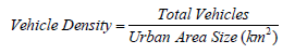
where vehicle density represents the number of vehicles per square kilometer of urban area (Table 5).

Table 5: Iillustrates the average vehicle density (vehicles/km²) across EU cities, highlighting that Athens exhibits a substantially higher vehicle density per 1,000 population relative to the European average.
Discussion
Air pollution represents a critical indicator of inadequate public health protection. Access to clean air is closely linked to reduced disease incidence and increased life expectancy. Populations residing in regions with higher air quality such as mountainous areas typically experience better health outcomes and greater longevity. The author expresses a strong commitment to fostering informed dialogue and developing innovative, forward-looking solutions concerning air quality, the assessment of environmental indicators, and the scientific classification of statistical data. A sustainable future must be grounded in rational, evidence-based strategies, with shared civic responsibility playing a pivotal role in promoting the health and long-term resilience of both communities and urban environments.
The foundations of medical geography date back to Hippocrates and his seminal treatise De Aere, Aquis et Locis. Although the concept is ancient, the term “medical geography” has been employed in England for over six decades. Dr. Alfred Haviland notably advanced the discipline in his 1892 work, The Geographical Distribution of Diseases in Great Britain [19]. Health-related ecological mapping can contribute meaningfully to both theoretical frameworks and practical applications in urban planning [20]. Moreover, contemporary Geographic Information Systems (GIS) technologies enable complex spatial comparisons, though these may occasionally be detached from their original contextual grounding [21-24].
Acknowledgement
I would like to extend my sincere appreciation to the Editorial Team of the American Journal of Biomedical Science & Research for the invitation to contribute my perspectives on the intersection of cartographic science and public health. The digital visualization of health-related data serves as a critical tool in addressing poverty, reducing social disparities, and advancing environmental protection initiatives.
Conflict of Interest
None.
References
- Jarvis DJ, Adamkiewicz G, Heroux ME, Rapp R, et al. (2010) Nitrogen dioxide. In WHO guidelines for indoor air quality: Selected pollutants. World Health Organization.
- Faustini A, Rapp R, Forastiere F (2014) Nitrogen dioxide and mortality: review and meta-analysis of long-term studies. European Respiratory Journal 44(3): 744-753.
- Chen TM, Kuschner WG, Gokhale J, Shofer S (2007) Outdoor air pollution: nitrogen dioxide, sulfur dioxide, and carbon monoxide health effects. The American journal of the medical sciences 333(4): 249-256.
- Stewart AE, Bolton MJ (2023) Digital weather information in an embodied world. In Informatics 10(1): 13.
- Åkesson M (2009) Digital innovation in the value networks of newspapers. Department of Applied Information Technology; Institutionen för tillämpad informationsteknologi.
- Berkhout F, Hertin J (2004) De-materialising and re-materialising: digital technologies and the environment. Futures 36(8): 903-920.
- Blaschke T, Lang S, Lorup E, Strobl J, et al. (2000) Object-oriented image processing in an integrated GIS/remote sensing environment and perspectives for environmental applications. Environmental information for planning, politics and the public 2(1995): 555-570.
- Pearce W, De Gaetano C (2021) Google Images, climate change, and the disappearance of humans. Diseña (19): 3-3.
- Moore ID, Grayson RB, Ladson AR (1991) Digital terrain modelling: a review of hydrological, geomorphological, and biological applications. Hydrological processes 5(1): 3-30.
- Moura Bueno JM, Dalmolin RD, ten Caten A, Ruiz LFC, et al. (2016) Assessment of digital elevation model for digital soil mapping in a watershed with gently undulating topography. Revista Brasileira de Ciência do Solo 40: e0150022.
- Turner MG (2005) Landscape ecology: what is the state of the science? Annu. Rev. Ecol. Evol. Syst. 36(1): 319-344.
- Hirt C (2014) Digital terrain models. In Encyclopedia of geodesy 1-6.
- Peitz M, Waelbroeck P (2006) Piracy of digital products: A critical review of the theoretical literature. Information Economics and Policy 18(4): 449-476.
- Popkova EG (2020) Quality of digital products: theory and practice. International Journal for Quality Research 14(1): 201.
- Bonneuil C, Choquet PL, Franta B (2021) Early warnings and emerging accountability: Total’s responses to global warming, 1971-2021. Global Environmental Change 71: 102386.
- Grossiord C, Buckley TN, Cernusak LA, Novick KA, et al. (2020) Plant responses to rising vapor pressure deficit. New phytologist 226(6): 1550-1566.
- New M, Todd M, Hulme M, Jones P (2001) Precipitation measurements and trends in the twentieth century. International Journal of Climatology: A Journal of the Royal Meteorological Society 21(15): 1889-1922.
- Easterling DR, Arnold JR, Knutson T, Kunkel KE, et al. (2017) Precipitation change in the United States.
- Gilbert EW (1958) Pioneer maps of health and disease in England. The Geographical Journal 124(2): 172-183.
- Barton H (2005) A health map for urban planners. Built environment 31(4): 339-355.
- Dorling D (2004) Healthy places, healthy spaces. British medical bulletin 69(1): 101-114.
- Chaziris A, Yannis G (2023) A critical assessment of Athens Traffic Restrictions using multiple data sources. Transportation Research Procedia 72: 375-382.
- Encyclopædia Britannica. (2025). Berlin. In Britannica.com.
- Wikipedia contributors (2025) Public transport in Athens. In Wikipedia, The Free Encyclopedia.


 We use cookies to ensure you get the best experience on our website.